Thermal Drone Applications

Thermal imaging in drones has been gaining popularity in recent years as this technology has become more accessible with significant price decreases in recent months.
There are an array of solutions for which thermal imagery from a drone is an ideal tool. From pest detection (wallabies, deer, pigs etc), power line and solar panel inspections to search-and-rescue and fire hot spot detection, the list of applications keep growing.
In this article we are showcasing a selection of applications our customers in New Zealand have been using with thermal drones.

What is a Thermal Camera?
A thermal camera records the temperatures of various objects within the frame and then assigns each temperature a colour, this lets you see how much heat is radiating from one object in comparison to other objects around it. Thermal cameras can detect different temperatures by recognising different levels of infrared light which are not visible to the naked eye. All objects emit infrared radiation which is how heat is transferred. Thermal cameras see this radiation and convert it into an image that we can see. Inside the thermal camera are devices called microbolometers which are used for capturing infrared radiation, each pixel has one of these. The microbolometer is responsible for recording the temperature and assigning that pixel a colour for us to see on screen.
Water Leak Detection:
Thermal drones can detect water leaks by differentiating between the surface temperature of the land depending on the water present. This application is ideal for agricultural customers who want to ensure there are no leaks throughout their irrigation system. One of our customers, Cardno used a thermal camera to identify a mysterious water leak on a construction site, read more about that project here.

The arrows on the map depict the underground water flow paths as scanned by the ground penetrating radar. Image supplied by Cardno.
Solar Panel Inspection:
As seen from the images below thermal drones are an effective tool for identifying faults in solar panels. As can be seen on the below image the yellow cells show the inspector exactly which cells have a fault. With the R-JPEG files created from the Zenmuse H20T and Mavic 2 Enterprise Advanced the exact temperature of certain pixels can be identified as well as the geocoordinate.

Image taken on a DJI Matrice 300 RTK with H20T

Image taken on a DJI Mavic 2 Enterprise Advanced

Image taken on a DJI Mavic 2 Enterprise Advanced

Image taken on a DJI Mavic 2 Enterprise Advanced
Thermal Hunting and Pest Control:
A thermal drone is a great tool for one of New Zealand favourite pastimes, hunting. As you can see from our customers' videos at a height of 70 meters animals are not disturbed by the drone and can easily be identified. This same technique can be used for monitoring pests and other animals. The Mavic 2 Enterprise Advanced is an ideal tool due to its size and portability.
Power Line Inspection:
High resolution thermal cameras can gain access to hard to reach areas and offer valuable imagery to detect potential faults with power lines and other infrastructure. The H20T as well as having a high resolution thermal camera has a super zoom camera with the ability to match thermal imagery with high resolution RGB imagery,

Image taken on a DJI Matrice 300 RTK with H20T

Zoomed in image on fault taken on a DJI Matrice 300 RTK with H20T
Fire Fighting:
Fire and Emergency New Zealand have been deploying drones for several years to assist with emergency responses. One of the most effective applications is the ability to map an area where a fire has taken place. From this map hot spots can be identified (not visible to the human eye) with geo locations for the ground crew to extinguish. Read more here about FENZ use of drones.
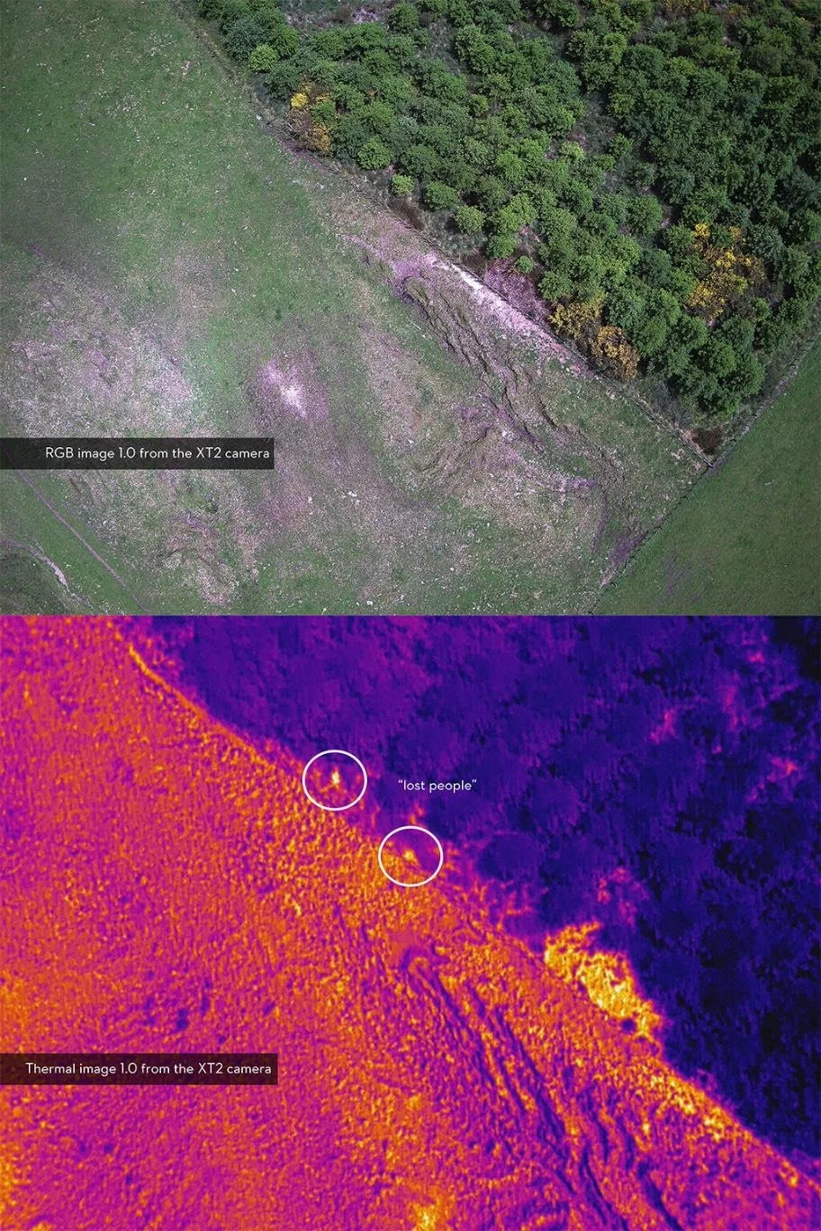
Search and Rescue:
Search and rescue operations are tremendously resource-intensive. There is generally a delay in getting a helicopter deployed to the location and the costs are large. Drones, equipped with high-powered thermal and zoom cameras, are now considered a vital tool in search and rescue operations, and it’s easy to see why. Ferntech have recently sponsored Youth Search and Rescue to put two of their cadets through a 101 RPAS course. Read more about Drones in search and rescue here.
Recently, the thermal imaging capabilities of DJI drones have been instrumental in helping customers throughout New Zealand improve the safety and performance of jobs. These are just a small number of examples demonstrating how thermal drones are helping organisations and businesses operate more efficiently with less risk.
If you’ve been wondering if it’s time to upgrade to a drone with thermal imaging capabilities, this post is designed to help you better understand the various applications.
| M300 w/ H20T | Mavic 2 Enterprise Advanced | |
|---|---|---|
| Max Flight Time | 43 Min | 31 Min |
| Wind Resistance | 15m/s | 10m/s |
| Multi Payload | Yes | No |
| Price | $$$ | $ |
| Water Resistance | Yes IP44 | No |
| Obstacle Avoidance | Yes | Yes |
| RGB Camera Resolution | 20MP | 48MP |
| RGB Camera Zoom | 200x Zoom | 32x Zoom |
| Thermal Camera Resolution | 640x512 | 640x512 |
For any further information visit the links below alternatively you contact us at commercial@ferntech.co.nz or call us on 09 399 2084.