
SOFTWARE SOLUTIONS FOR FLEET MANAGEMENT
Drone platforms have proved a valuable resource for a host of industrial applications, but the expansion of drone operations has also presented a difficulty for scale management, standardising procedures, and ensuring reliable regulatory compliance. Fleet management software helps effectively manage multiple crafts and missions.

DJI FLIGHTHUB 2: ELEVATED AWARENESS. MAXIMIZED INTEGRATION
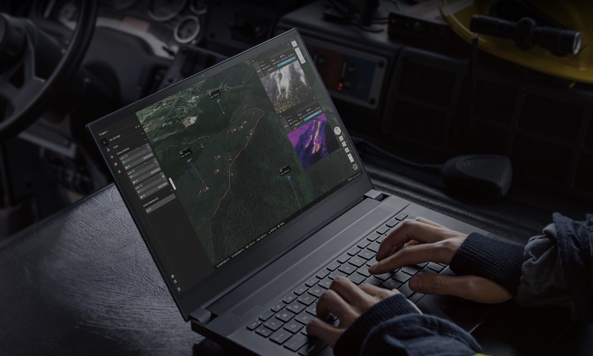
The DJI FlightHub 2 is DJI Enterprise’s fleet management software. It benefits from major improvements from its first version synchronizing and coordinating between ground teams at work, drones, payloads, pilots and all the data they gather. The DJI FlightHub 2 is now entirely cloud based. It enables flight mission management and operational viewing not only from the pilot’s RC, but from any device with a web browser, such as computers, tablets, and even mobile devices. Now, everyone involved in a drone operation, from ground teams to nearby supervisors to managers in their offices, can log into the same mission and see the data gathered by the drones and the pilots.
The DJI FlightHub 2 supports mapping features enabling users to respond quickly to developing situations.
One-Tap Panorama Sync creates a 360° overview and uploads to the cloud with a single tap. Shared panoramas, and the coordinates they were captured from, are placed on your mission's 2.5D Base Map, granting all team members quick aerial awareness.
Cloud Mapping lets users highlight an area of interest, enabling the DJI M30 to automatically map the area in 2D, offering great perspectives during emergency response planning situations. DJI FlightHub 2 will turn these images into a map, which will overlay on the user’s map service provider. Once a map is captured, it can become the base to build a mission plan around.
The DJI FlightHub 2 supports Live Annotations, which are points, lines, or polygons that users can draw on the map. Thanks to the laser rangefinder of the DJI M30, in a search and rescue mission, a pilot can pinpoint the coordinates of a missing person. These coordinates will automatically sync through the DJI FlightHub 2 mission interface allowing the command center and the team on the ground to have live updates of coordinates and to simultaneously generate rescue routes. All these maps, models and inspection data can be uploaded to the cloud, supported by AWS, and accessed and managed remotely.
DJI FlightHub 2 becomes must-have software to streamline communication between the command room and the team on ground, and manage real-time missions.

DJI fLIGHTHUB
DJI FlightHub manages your drone operations with the industry's first web-based management solution. The software gives operators the ability to manage live operations, organise fleets, and log all of their historical flight data. Empower your team with greater coordination between pilots in the field and analysts in the office.
FlightHub allows the user to see real-time telemetry data of all of their drone operations through a simple map view giving not only additional clarity of time and location but also ensuring that all pilots are conforming to industry and organisational standards. FlightHub also allows for up to four simultaneous live streams in a single screen for ultimate visibility of all drone operations, and better decision making for real-time incident command teams. The software gives service providers and drone teams a one-stop location to manage and aggregate their flight data.

AVCRM RPA MANAGER NEW ZEALAND
No matter whether your organisation operates under Part 101 or Part 102 the AVCRM RPA Manager is designed to improve efficiency in RPAS operations both in the office and in the field. Mission planning, safety and risk assessments are easily completed on our responsive web-based platform that improves operator situational awareness, ensures appropriate equipment and personnel are being deployed and gives live management oversight and intervention as required.
Record keeping is an integrated part of AVCRM’s philosophy, meaning that we aim to keep data entry as close to single point as possible. This improves the accuracy and efficiency of aspects like Pilot Logbooks, Defect Management, Flight Telemetry and many more.
With an ICAO standard Safety Management System onboard the AVCRM RPA Manager is a powerful choice for small or large operators of Unmanned Aircraft. Not only does it cater for standard risk assessments and safety reporting but the integration between modules allows effortless attachment of associated mission plans, job safety assessments and other relevant data into your safety reporting.
Connected to multiple data sources, AVCRM gives users finger-tip access to important operational information including New Zealand national airspace, aerodrome and heliport locations, special use airspace, conservation and national park areas, district council areas, radio frequencies, high tension power lines and much more. With the toggle of a switch our Smart Airspace Calculator takes the confusion out of accessing aviation charts and maps, only displaying airspace and data layers relevant to your planned mission location and height as well as displaying the relevant rules and advisories for RPAS operations under Part 101. Another toggle of a switch will show rules and airspace threats relevant to Shielded operations as required but the type of operation being conducted.
HIGHLIGHTS
JSA & Job Manager - Customisable job creation and approval with integrated airspace maps
Airspace Calculator - Integrated airspace maps automatically identify fly/no-fly zones
Pilot & RPA Logbooks - Keep track of controller and RPA total time in service logs
Maintenance Manager - Manage all RPAS Maintenance and defects tracking requirements
Battery Management - Track battery usage, cycles and health. Be notified when batteries need maintenance.
Flight Sync - Automatically Sync flight and telemetry data from your DJI account and create custom reporting and notifications.
Qualifications & Training - Manage all staff qualifications, inductions and assessments on any device.
Safety Management - Manage hazard identification, accident reports and Drug and Alcohol Management Plans.